Filmore Loop #03 Filmore Loop #03
The Fillmore Loop is like a giant triangle with the town of Fillmore at its apex and a portion of the main Paiute Trail as its base. The whole loop takes three and a half to four hours to ride. Approximate Section Time
· North Leg -
Chalk Creek and Bear Hollow Road Fillmore to Main Paiute Trail -- 1.5 hrs
· East Leg -
Main Paiute Trail Bear Hollow Road to Sand Rock Ridge Road ----- 1 hr
· South Leg -
Sand Rock Ridge Road Main Paiute Trail to Fillmore ------------------- 1 hr
Fillmore is the low point of this loop at 5,150 feet. The north leg of the loop rises gently along Chalk Creek to 6,400 feet before climbing the north wall of the canyon to a high point of 9,500 feet and then joining the main trail at 9,200 feet. The south leg of the loop leaves the main Paiute Trail at 9,680 feet, rises to a high point of 10,010 feet near White Pine Peak, and then descends to Fillmore. White Pine Peak itself rises to 10,216 feet. 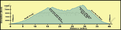
The north leg of the trail from Fillmore follows paved roads for several miles to about the Forest boundary. These paved roads can be treacherous for low-pressure tires and must be driven with extreme caution. At about the Forest boundary the trail enters the narrow canyon of Chalk Creek, while the paved road swings onto a bench south of the canyon, the trail follows an old dirt road that was washed out in the spring floods of 1983. This road is narrow in places and crosses Chalk Creek several times at undeveloped crossings, some of which are quite deep. Because of the narrowness of the canyon there are no camping spots downstream from the picnic grounds. 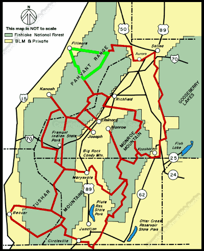
continued next page
|