Fremont Indian State Park or Castle Rock Campground to Circleville
The ride from Fremont Indian State Park or Castle Rock Campground to Circleville takes about eight hours. Intermediate times for this portion of the trail are as follows:Approximate Section Times
· Castle Rock Campground to Kimberly ------- 2 hrs
· Kimberly to Junction with Marysvale Loop - 0.5 hr
· Marysvale Loop to trail's highest point ------ 1.5 hrs
· Trail's highest point to Utah Highway 153 --- 1 hr
· Highway 153 to Big Flat -------------------------- 0.5 hrs
· Big Flat to Grindstone Flat ----------------------- 1 hr
· Grindstone Flat to Circleville -------------------- 1.5hrs
Starting at the 5,800 foot elevation at Fremont Indian State Park, the trail follows Mill Creek up to the old mining town of Kimberly at 9,400 feet. It then crosses to the Beaver Creek drainage and the Marysvale Loop at about 8,800 feet. Following Beaver Creek for about six miles the trail rises to its highest point of 11,500 feet at the pass between Mount Belknap and Delano Peak. It then descends and crosses the southern end of the Tushars between 9,000 and 10,500 feet before descending Wades Canyon to Circleville at 6,000 feet. 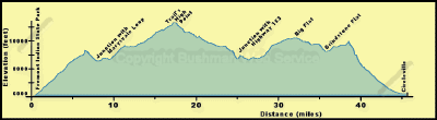
For those starting in Castle Rock Campground, the trail goes north along the frontage road (Forest Road 478) to the bridge across I-70. Here the trail joins the one coming from Fremont Indian State Park. For those starting at Fremont Indian State Park, the route follows Utah Route 4 to Forest Road 113 where it turns south for about a mile to join the route coming from Castle Rock. 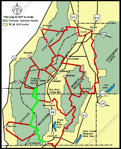
continued next page
|